Hi fellow flyers,
I am reaching out to the collective knowledge and experience of you all as I am planning a trip to Budapest on the coming weekend.
I do have also regular airline tickets as a backup, as I wanted to make sure to take out any pressure from the beginning. The plan would be to leave LIDT on friday noon, and fly to LHBS. So far, so good.
I usually begin monitoring the weather forecasts a few days ahead, and over the years find myself using more and more Windy. The friday is looking not so bad from a cloud perspective:
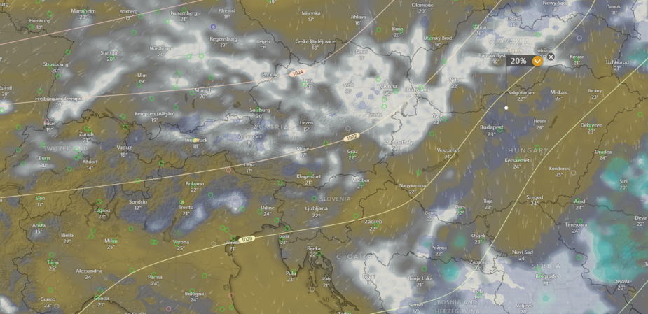
However, what bothers me are the winds and in particular the predicted wind gusts:
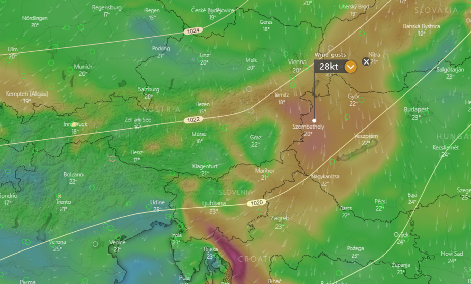
When flying out of Innsbruck anything above 20kts is usually a no-go for creature comfort around the mountains, depending on the destination and track. It looks that where Windy depicts the gusts it’s mostly flatland, and an area where I would plan to sit higher, say FL75.
What would be your train of thought on these circumstances? I am curious to learn how others would approach this.
Thank you!
Lukas
I don‘t know if the gusts are also forecasted at FL75? Normally I would expect a turbulence warning, not the indication of gusts. But regarding your planing, if Budapest is fine regarding wind direction and gusts I wouldn’t catr about the small region of possible turbulence on the way.
Hi eddsPeter,
thanks. In theory gusts are forecast on 10m above ground, so indeed at higher altitudes those should not be a factor. It’s all my flying in the Alps that makes me think exactly opposite it seems :)
lukepower wrote:
However, what bothers me are the winds and in particular the predicted wind gusts:
I would be more worried about vertical development clouds because I’m pretty sure you can expect a lot of convective activity later on during the day, probably peaking between 11 and 14 UTC. The planned altitude 7500 ft definitely won’t be enough to top up these clouds. I even can’t say if this will be ok altitude for avoiding because it can be just at cloud base altitude where the clouds will occupy the most area. I would initially fly 10000 ft or so in direction of Zagreb and then gradually lower the altitude passing hills around Zagreb and going to flatlands. I guess this is VFR flight, so my idea would be to climb high initially to increase visibility for tactical avoiding and then to go lower below potential clouds in the landing area. In-flight weather tools like ADL would be of great help.
I would look at wind/gust in various altitudes as well, 25kts is too windy with terrain (worth cross-checking against QNH delta  )
)
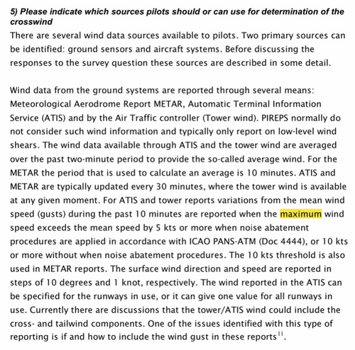
Just a small detail on Windy surface wind/gusts they are not RWY surface wind/gusts, you will find that they are slightly overestimated in Windy versus ATC, ATIS, METAR
Ignoring: terrain errors, interpolation errors, forecast/nowcast errors
Obviously, there is some proportionality going on, it’s hard to disregard due to definitions
[ links cleaned up ]
There is a mix-up between two things here.
At altitude, there are no gusts, so none can be forecast. Wind flows smoothly, unless it is close to terrain and then you get turbulence. For example a 40kt wind flowing over mountain ridges will produce a lot of turbulence unless you are about 4000ft+ above the ridges. There is a rule of thumb which is something like 10kt of wind produces 500fpm when 1000ft above the ridge, so if you are cutting it close you want really no wind. And there are well developed strategies like crossing ridges at an angle, not at 90 degrees, flying on the side of a valley where there is an updraught, etc.
When flying out of Innsbruck anything above 20kts is usually a no-go for creature comfort around the mountains, depending on the destination and track.
This is LOWI
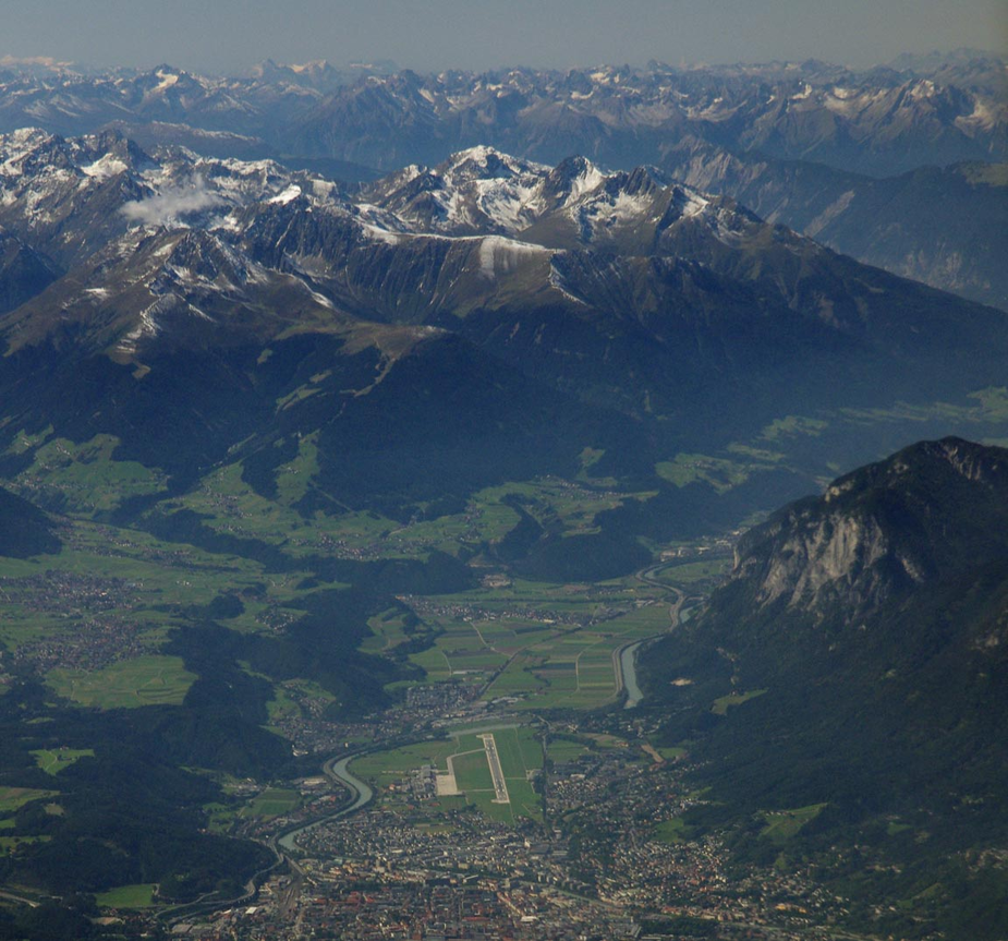
It is at the bottom of a vast valley. The effect of wind will depend on your departure route and how close it goes to the terrain. If one climbs on the runway bearing, towards the camera in the above pic, and climbs to say FL150, one will not have any trouble with the LOWI METAR showing say a 20kt wind. But if one climbs up to say 1000ft above the terrain around the airport, a 20kt wind at the airport will probably be 40kt up there and it will be rough.
Remember surface gusts are just a higher level wind (which may be quite smooth) occassionally dropping down to the surface.
So altitude is your friend.
It looks that where Windy depicts the gusts it’s mostly flatland, and an area where I would plan to sit higher, say FL75.
I don’t see how Windy can forecast turbulence aloft, relevant to GA. Jetstream, maybe…
Surface gusts can be estimated, which is how they can do it in TAFs. Whether G20 on the runway affects you depends on the plane and your experience. A real 20kt variation in the reported wind (officially, measured on a 10m pole) will produce quite a lot of variation in the wind shear. If say the wind is 30kt G50 and down the runway, you have a fair bit of wind shear due to the 30kt, plus you will have a variation in the wind shear due to the 20kt gusts. But this is simplistic… I know someone who landed a TB20 in a 50kt wind on the runway bearing and well and truly bent it because he forgot about the inevitable wind shear. All wind produces a wind shear (= variation of wind with altitude; nothing sinister) and 50kt is a lot of variation, especially in the last 20-30ft.
For surface gusts, use TAFs For airborne turbulence, fly a few thousand feet above the terrain.
I have often found that Windy gust forecasts are a lot higher than gusts turn out to be in reality. I would look at the METAR and TAF on the day they tend to be a lot better than Windy. They usually get the steady wind ballpark right though.
Cloud tops and cloud base forecasts are not amazing generally (at least in the UK). Again I would suggest to look at METAR and TAF on the morning for cloud base. For cloud tops what I do is look at the IR satellite on the day and look for the temperature of the tops. Then look at the temperature at altitude chart on Windy and you can use that to estimate where the tops ought to be. If there is convection in the vicinity of the airport (CBs or Thunderstorms) they’ll tend to be in TAF/METAR, but you can also look at Cape index in Windy which can estimate how much energy is available for thunderstorm development. There is also a special “thunderstorm” layer in Windy which has thunderstorm forecasts. I wouldn’t count on it to be precise in terms of where it’s going to be. If you’re going to be flying high don’t forget to look at the icing level.
I have often found that Windy gust forecasts are a lot higher than gusts turn out to be in reality. I would look at the METAR and TAF on the day they tend to be a lot better than Windy.
See my comment on gust definition, I would expect METAR gust factor to be 1/2-2/3 of Windy gust factor even when looking at T0 nowcast data right after an update
Ibra wrote:
See my comment on gust definition, I would expect METAR gust factor to be 1/2-2/3 of Windy gust factor even when looking at T0 nowcast data right after an update
That’s interesting, just read that through, that’s very good to know.