Hi. In EU all ILS approaches have “DME mandatory” so we display distance on DME, easy.
In US way, normally noone have DME anymore and you use GPS for distance check however how you setup for example GTN650 to have it displayed all of the time.
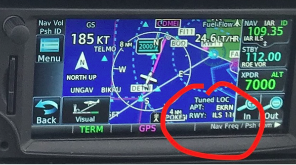
I tried to make box with “current vor selected” what shows normally radial + distance to vor but during approach mode its shows only RWY11/ILS and no distance.
I’m asking how to program/setup GTN to have always visible distance to aid.
Second problem is that during approach “distance to next” will always show next point from approach way, not distance to ifr nav aid from chart….
FPL page with cumulative distance field configured?
lionel wrote:
PL page with cumulative distance field configured?
Yes but how to see on on moving map. On approach I want to have all on one screen with no need to concentrate on GTN when I fly approach, missed etc.
Let’s say I’m looking for alternative for DME. Dme always shows just distance to navaid, always visible..
I have not used GTN650 but I think you can replace “Fuel flow” top right with “distance to next waypoint”? in personalisation menu
If you have approach loaded RNP or ILS Overlay, you will see distance to threshold RWY11 on final
Przemek wrote:
In EU all ILS approaches have “DME mandatory”
They don’t. There are many ILSes around that don’t require DME. But I agree that many do so in practise you do need a DME.
so we display distance on DME, easy.
In US way, normally noone have DME anymore and you use GPS for distance check however how you setup for example GTN650 to have it displayed all of the time.
I tried to make box with “current vor selected” what shows normally radial + distance to vor but during approach mode its shows only RWY11/ILS and no distance.
I’m asking how to program/setup GTN to have always visible distance to aid.
Second problem is that during approach “distance to next” will always show next point from approach way, not distance to ifr nav aid from chart….
Beside the technical problem there is a regulatory problem. You are not allowed to use GPS instead of DME! (With rule changes this autumn the restriction will be marginally changed – you may now use GPS if you have a DME that was serviceable at takeoff but breaks in flight!)
The US has different practices on how to install DMEs – they don’t use offset DMEs and they don’t use the same id for a DME and another navaid unless they’re colocated. Both of these things can happen in Europe. The first one means that you can’t just replace the DME distance with GPS distance to the DME while the second one means that you may take the GPS distance to the wrong navaid. The Dundee crash showed that these risks are real.
OTOH, the blanked ban on GPS substitution is over the top IMO. The restriction is in an AMC so in principle you may (under part-NCO) come up with your own alternate means of compliance.
One AMC is if you are in a radar environment you both can fly the approach, and request a range check at the glide slope check point.
Typically in the USA you use the IFR database to provide distance by activating an overlay approach. While you are not flying magenta, the strip information will provide accurate distance to FAF and MApT in sequence.
In the UK we are allowed to use GPS overlay up and until the FAF, then terrestrial (including the mystic ADF). As far as I can tell, this is a unique example of a Brexit dividend.
Even in Germany, several ILS approaches no longer require DME.
boscomantico wrote:
several ILS approaches no longer require DME.
“no longer”? What has replaced DME? In my experience it is usually the other way around – existing ILS installations have marker (or locator) beacons replaced by DME fixes.
Don‘t know. But I was only talking about legalities here. Unto a few years ago, all ILS plates in Germany had a box „DME required“ on them. Now, many still do but more and more don’t. Luebeck is an example.
I removed my non-functioning DME last year, and have in practice had no issue because I use RNP approaches as primary and the ILS only as a backup. In the event I need to rely on the ILS, for example because of minimums which are sometimes lower, RobertL18C’s method works fine. Even when I don’t plan to fly the ILS I will check to see if there’s an appropriate GPS point to base distance from in case I need it.