@jeff64 pointed me to the EUROC charts available on the Aeroweb site – https://aviation.meteo.fr/accueil.php#debut_page
I used them for a flight to Kotritjk on Thursday and it was pretty much bang on. There was a layer of BKN Cu out of Kemble and various layers into Kotritjk and Cu up to FL120 or so. I forgot to save the chart but very accurate.
Yesterday I flew to Dalaman, and the accuracy of these charts was amazing. The high level stuff was exactly where it was and we had light to occasional moderate as forecast on the route down.
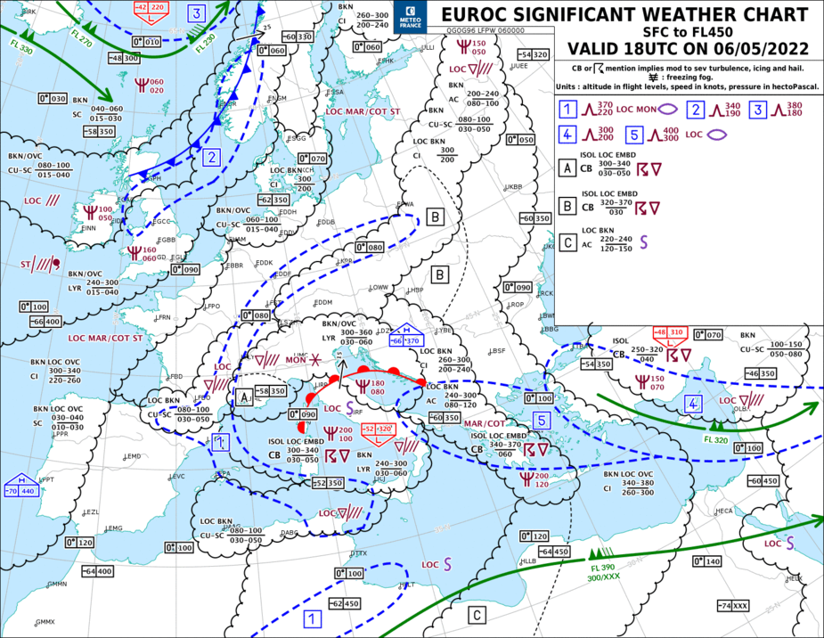
As you can see, passing Munich the warm front starts to appear and the high level layers associated with it. Very accurate for IFR planning and making a decision.

Then the layer associated with it. Very accurate depiction of weather from SFC+
Anyone used?

The EUROC or as they used to be called TEMSI are imho the best SWC’s for Europe and particularly for GA. I’ve been using it since ever it became available many many years ago.
Normal SWCs have a bottom level of FL100, which makes them irrelevant for most GA flying. There are some LLSWC’s issued by various countries, but imho the EUROC chart is quite universal as it covers SFC to FL450 and also geographically covers most of Europe.
That is TEMSI chart, it’s Météo France equivalent of UK MetOffice F215, if you use AutoRouter Bot just send “TEMSI” and he will reply back 
Anyone used?
Some mainland instructors say you need to have printed TEMSI & F215 to fly legally under IFR in Europe
I recall one examiner asked about few symbols in F215 & TEMSI charts (appatently, none of us seems to know what those means except on the exam day)
In the airliner context, wx forecasting is pretty good because they can outclimb it 99+% of the time, and they have good ice protection, radar, etc.
Those charts were for many years known as SigWx. They used to depict fronts also but they were removed under an ICAO directive. I don’t think @bookworm is here anymore but he was involved with that at the time.
Peter wrote:
Those charts were for many years known as SigWx. They used to depict fronts also but they were removed under an ICAO directive. I don’t think @bookworm is here anymore but he was involved with that at the time.
The Fronts were removed on most SWC’s because their lower limit became FL100. You can’t realistically put frontal symbols for a front on the ground (which is what the popular symbols are) on such a map, because the front on the ground is outside the altitude limit. The SWC’s issued by the WAFCs don’t therefore show them anymore.
That is one reason why the EUROC and TEMSI (they are two different charts but both from SFC to FL450) still have the fronts on them. And that is why they are extremely popular, as they really give the whole picture, SFC to up to where most peple care about.
I recall they disappeared for a while from some briefing packages due to copyright issues (or rather, the applicable weather service did not want them there, as they come from the French competitors) and it caused a small revolution with the airline pilots using that facility. They were implemented back P.D.Q.,
Ibra wrote:
I recall one examiner asked about few symbols in F215 & TEMSI charts (appatently, none of us seems to know what those means except on the exam day)
I have to look for it, but there is a lovely little PDF someplace in English which gives the complete set of symbols and explanations. One of the more useful things I ever studied in my time. The French version (with details for each chart) can be found here. IMHO very well worth the read.
Peter wrote:
In the airliner context, wx forecasting is pretty good because they can outclimb it 99+% of the time, and they have good ice protection, radar, etc.
That is too easy. For airliners, simply the problems are different. They can easily get around some stuff we dread but they still need very accurate forecasts in other aspects. In particular, winds aloft packages have a huge impact on their operations, so do TAF’s and LTAFs, which in many ways lay down the law on their ops.
As GA and particularly low level GA (altitude wise) we have different issues and different needs. But neither of the two are less complex or require more or less exact forecasting.
Ibra wrote:
Some mainland instructors say you need to have printed TEMSI & F215 to fly legally under IFR in Europe
They should read NCO.GEN.135 and its Guidance Material.
In particular, winds aloft packages have a huge impact on their operations
Sure, but they do have this – from ADS-B OUT data showing TAS and GPS GS Winds aloft at jet altitudes are accurately known these days.
Piston planes are perf limited most of the time, relative to wx.
IMHO the SigWx charts have limited value to piston GA. They are a bit like the UK Met Office F215 – contains everything on one page 
And windy.com beats the whole lot.
contains everything on one page and windy.com beats the whole lot.
I guess for start one can look at F215/TEMSI? but I think having access to more raw data from various benchmark models and visualisation tools AND actually flying aircraft in few forcasts tend to offer better pilot understanding of weather at cruise levels
Have been using information.from Aeroweb for years EUROC, Temsi, satellite, radar, IR etc. frontal charts, TAF, Metar, winds at various levels. And like Pilot Robbie I have usually found them accurate. I don’t bother going anywhere else.