Airborne_Again wrote:
Sorry Peter, but you’re wrong. NDBs have been used for enroute navigation in most (*) European countries well into the 1990s. Not much, certainly, but here and there.
Yes, in many places NDB’s were used until GPS was firmly established. Why not… unless there is convective activity they are quite reliable.
In the east block they relied very heavily on NDB’s, in some states to this day. Almost all the navigation we did in the TU154 transition was NDB based and the only Nav radio the AN2 had was a huge ADF.
I remember flying into the Canaries on the Caravelle before we had the Garmin 100 AVD glued onto the dashboard. Usually the first radio to be received from the Canaries was a beacon somewhere on top of a mountain on Tenerife (I believe it’s callsign was FP but not sure anymore) which was reachable long before the VOR’s gave any reasonable bearing.
Also the one on the south tip of Greenland (Prins Christian Sund?) used to be very widely used for crossbearings on NATL crossings, even with the Rich Air DC8 I flew on several times to MIA and back.
That was in between 1990 and 1993.
LeSving wrote:
How are these DMEs used?
They are used by the pilot to determine distance from the threshold. IFR approaches have check fixes where the pilot should check that the glidepath altitude is correct. (Yes, simplified.) Historically, these fixes were determined using NDB locators or marker beacons, but they are increasingly being replaced by DME distances.
Cobalt wrote:
Are these really two different DMEs at each end, or one DME that is active for the runway in use?
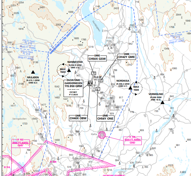
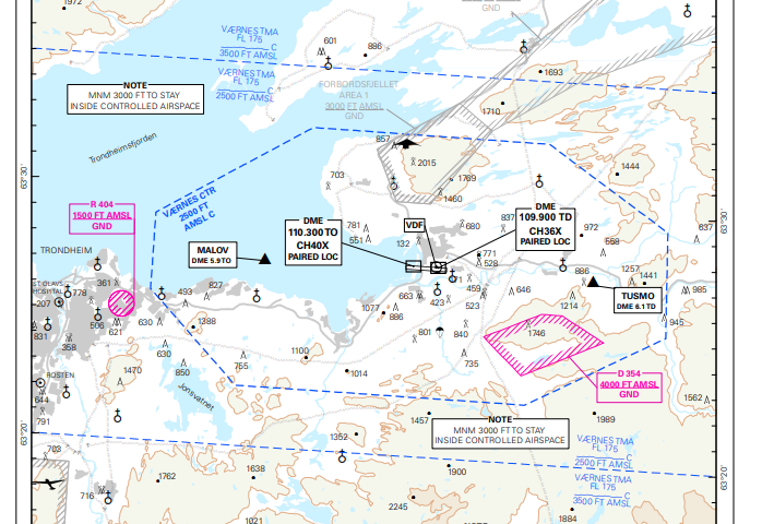
I don’t know, but they certainly looks like two separate DMEs, one at each runway end. They are shown in particular on the “visual approach chart”. It’s the one we usually also use for VFR, with a couple of exception. At ENGM there are four. One at each end of each runway.
LeSving wrote:
two DMEs, one at each end of the runway.
Are these really two different DMEs at each end, or one DME that is active for the runway in use?
I don’t think two DMEs that close to each other are very useful; in order to get a position fix you need at least three DMEs (well, two if you can rule out one of the points definitely) and they cannot be too close to each other, and especially not “behind” each other as seen from the aircraft;. The closer they are (and the narrower the angle as seen from the aircraft) the less precise the fix will be.
T28 wrote:
Yes, there are DME / DME procedures. But you need to have an inertial reference unit installed (and working).
OK, but how is it used, what is the system and principle of operation? and why 2 DMEs?
Is the INS the primary system and DMEs are correcting it? Then why have an INS at all, when you have two DMEs ?
Yes, there are DME / DME procedures. But you need to have an inertial reference unit installed (and working).
Caba wrote:
DME/DME
Just wondering. In Norway I see that NDBs around airports are going away and being replaced by two DMEs, one at each end of the runway. How are these DMEs used? Do the airlines have some automatic system that use these DMEs to pinpoint the position, like a moving map GPS kind of thing?
In Germany we have areas with so many VORs and DMEs that I feel no one will ever have any problem whatsoever if a third or more were decommissioned, especially the VORs . Quite a few locator NDBs are still there too, but frankly I don´t have a clue why. Same goes for the one and only area NDB in the area. They might just be around until EASA gets rid of NDB questions in their QB. Just kidding, these should really be gone by now.
A few years ago we had a VORTAC notamed for like two years or so and everyone but the fighters flew the same SIDs and STARs using RNAV. Since that time I´ve been convinced it´s not a big deal putting many navaids offline while a few remaining ones retain conventional capabilities. For IFR flying I never use green needles unless I want to practice, as I think most of us could. Most airliners are RNP capable too nowadays, unlike a few years ago when a crew requested a GPS approach only to be embarrassed two minutes later after they had found out their jet actually featured no GPS.
For VFR, I really don´t need to have VORs at all. I will rely on GPS and if that or the antenna´s gone TU there´s still an iPad, a map, radar, radio and Mark I eyeballs. It worked 100 years ago on less equipment, we´ll cope I´m sure.
So in my view the bottom line is: ILS will be around for many more years, DME/DME will be used as RNP primary and backup especially for the airlines. Enroute VORs will be reduced to the absolute minimum for the worst contingency case you can imagine. NDBs will go away within the next decade.
NCYankee wrote:
In most instances, DME is retained when VOR is shut down.
This is the case here as well.
NCYankee wrote:
US has 4086 LPV published with 1057 using LPV200.
Good news for me is my home field, EHRD, went from LNAV+VNAV to LPV on both ends. So a net win in my book.
As long as you understand the limitations of NDBs they are a useful tool. Before they started to disappear in this area, I used to use them a lot for both VFR and IFR.