so he had to take a turn to the right and west of about 180 degrees
to go to his right course to memmingen.
but he did a turn of about 270 degrees.
Did you mean
he had to take a turn to the right and east of about 180 degrees
With a 23 departure, the above FR24 track doesn’t pick him up for quite a while, which is normal. The FR24 playback shows a steady controlled climb, but the right turn was continued for too long.
Or, he planned to make the turn tighter, which would have also avoided the terrain, but takes you over the built-up area
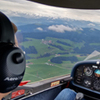
A VFR circuit in IMC? Did you see the webcam? That would have been outright suicidal
That is why I say go for straight-in departure & arrival on well planned IFR flight path that you plan and track on your FD/HSI, it’s stupid to fly low VFR navigation & circuits in IMC
In my opinion, the right visibility & ceiling to fly VFR navigation & circuit is 5km & 2000ft ceiling bellow that you operate IFR on your instrument (it’s a state of mind that involve having huge margins vs the ground and obstacles and zero margins vs clouds)
The reason why this discussion comes up so often is, that so often a pilot colleague of us again has tragically proven it is not safe. Therefore there is a good reason why it’s illegal!
You are preaching to the choir here. I fully agree.
It was purely for the purpose of analysis that I am trying to understand what this guy tried to do. And there is no explanation I can come up with which made sense until now. WIth the explanation that he had to take off on 23 due to noise restrictions, it becomes much more clear but also a lot more hazardous. To try to fly a circuit and then outbound from this circuit in full IMC…. words fail me.
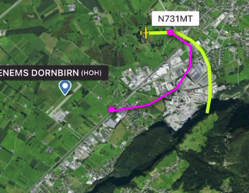
i could verify that he flew out 23
due to flight restrictions over the city of dornbirn (to the north).
so he had to take a turn to the right and west of about 180 degrees
to go to his right course to memmingen.
That explains a lot. So we are really look at a CFIT and a loss of orientation.
The speed indications from FR24 are notorious for doing weird things.
However, assuming they are correct, IAS was a bit on the low side for a clean aircraft (clean as you would expect well after the downwind turn). A P210 is speed-unstable below about 100KIAS when clean, especially if heavy. It is easier to handle it slightly above 100KIAS to minimize pitch and speed excursions with minimal attention.
I would want to free my mind from this if handflying in IMC at low altitude (ie I would fly 110 KIAS or, if concerned about turning space, use flaps 10). If on a/p even worse as an autopilot-driven stall is easy in this condition, again I would let it fly at 100KIAS or a tad more.
If zero wind, FR24 data would infer IAS below 90 in the small portion of the flight it reports, but ROC of 700fpm is consistent with climb power on a clean aircraft at that IAS at med-high weights
In general, I find little use for speeds below Vy (around 100KIAS on clean P210 depending on weight)…better leave that to the Eduardo’s and PilotDAR’s of aviation
lets sum up the facts:
(sorry if i use a language that every person interested or faszinated by flying could understand
regardless being a professional pilot or hot air balloon fan.
i think that relevance or accuracy of facts is not reduced by this more simple terms.)
- loih is a vfr airport only. no ifr clearance or possibility. there is no tower or radar control. pilots have to decide wether to land or to takeoff on their own judgement.
- there was (dense) ground fog. low visibility. fog from ground to about 300 to 600 feet. clear sky and fine weather above.
- austrian vfr rules for landing or take off at such an airport require 5km horizontal visibility and 1500 meter vertical visibility to lowest clouds.
otherwise you are not advised or allowed to land or to depart.
- pilot intended to fly to memmingen. a small airport north to loih.
- pilot had ir rating. plane was fully ifr equipped.
- due to flight restrictions over the city of dornbirn (north to airport) pilot flew out runway 23 (to the south).
(if he had used runway 05 to the north. he could have flown out practically on a straight course until climbing above fog level to vfr conditions).
- after takeoff pilot had to turn to the right (mountains on his left/eastern side) to circle to the west and north in an approx. less than 180 degree turn to get to his northerly course to memmingen airport.
- pilot circled (to the right) more then 180 degrees towards 270 degrees in obvious very poor visibility conditions to a course southeast
to crash into to steep mountainside that is northeast of loih, facing northwest.
- distance from runway to crashsite about 2,5 to 3,0 km.
- according to radar data given (not veryfied) climbing rate of plane from takeoff to crash has been stable.
- it all happened in a very small time window. from takeoff to impact probably less than 3 minutes.
Just wantet to throw in the relevant AIP for VFR Minimums in Austria. In the Table it says 5km Visability and free from clouds, but can be reduced to 1500m visability when flying in Class F and G below 140KIAS so you can avoid Traffic and obstacles (if 1500m is enough to avoid another traffic coming at you at 140KIAS or a Solid Rock is another Question)
As I said before, if he was IR rated why not just fly a proper IFR departure away from terrain, even in clouds no shame, no harm?
How do you fly proper IFR departure from a VFR only airfield? I’m asking for a friend 
This is how it looks on ForeFlight map, magenta line shows direction to EDJA (someone mentioned it was planned destination).
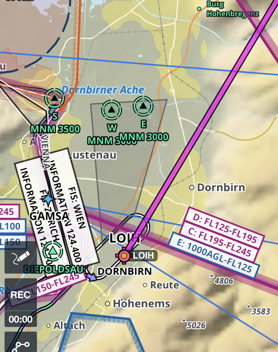
Just wantet to throw in the relevant AIP for VFR Minimums in Austria. In the Table it says 5km Visability and free from clouds, but can be reduced to 1500m visability when flying in Class F and G below 140KIAS
So, why did @cpt_om_sky state it is 5000m? He claims to be a local pilot (or instructor?).
1500m below 140kt and free of cloud is pretty standard.
The webcam vis wasn’t 1500m however.
How do you fly proper IFR departure from a VFR only airfield?
Obviously that was nonsense