Very sad indeed.
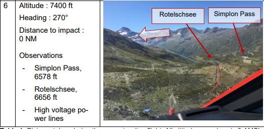
Actually the strangest thing is that he crashed at a higher altitude than the pass altitude itself. The reconstrcution flight shows a photo that, although it’s an unconfortable altitude for going through the pass, is still doable .
It’s unclear why he tried to either make a U turn or a 360 to gain altitude. In any case a lack of mountain experience.
I would say stickying to the right make a correct way to make the pass, as you have very nice visibility on the route. I didn’t fly there, but surely do.
greg_mp wrote:
Actually the strangest thing is that he crashed at a higher altitude than the pass altitude itself. The reconstrcution flight shows a photo that, although it’s an unconfortable altitude for going through the pass, is still doable .
Exactly and he was flying on the LEFT side of the valley, which is not normally done. You usually follow the right hand side.
The way I understand it, he defined a couple of waypoints to follow and did follow those strictly rather than follow the terrain. That does not make sense at all.
greg_mp wrote:
It’s unclear why he tried to either make a U turn or a 360 to gain altitude.
I think neither, he simply wanted to turn to his next waypoint or away from the mountain into the valley. And stalled due to too low speed and introducing bank.
greg_mp wrote:
In any case a lack of mountain experience.
I would say stickying to the right make a correct way to make the pass, as you have very nice visibility on the route.
Clearly lack of experience. From day one I was wondering how on a N-S passage he would end up in this position. That he flew straight towards that mountain only to turn late and too steep indicates that he got surprised by the approaching terrain. That should really not happen. He was well over ground elevation of the pass and could have crossed it in the center of the valley or just about anywhere but where he was.
The report sais he had already once crossed the pass from S to N on a previous flight. I’d be really interested to know which side of the valley he followed on that occasion.
I also fly with waypoints in the alps but it is pretty obvious you can’t fly those like RNAV procedures but they are rather there to calculate the distance of the flight and as a general aide memoire. In the valleys, only strict VFR is required which means watching out of the window.
And if there is a 2nd pilot on board, as it was here, she should be up front, not in the rear. 4 eyes see more than 2.
he was flying on the LEFT side of the valley, which is not normally done. You usually follow the right hand side.
From my limited training of Mountain flying in The States, I was taught that you fly on the UPDRAFT side of the valley – which could be either the left or right side – depending on the wind.
Mooney_Driver wrote:
And if there is a 2nd pilot on board, as it was here, she should be up front, not in the rear. 4 eyes see more than 2.
She probably sat in the rear seat to be able to care for their child.
Very sad accident for such lovely family, I am very puzzled as he flew that pass before?
Looks way too low for an Arrow and all it takes is seconds not paying attention outside
to remove
Peter_G wrote:
From my limited training of Mountain flying in The States, I was taught that you fly on the UPDRAFT side of the valley – which could be either the left or right side – depending on the wind.
Actually you have to assess the best place where to proceed, there is not hard rule apart from judging, depending on wind, sun side and reflection, and mountain profile. you can do either left or right, but it has to make sense with the situation (aka situational awarness). Going on updraft side if you can’t see the other side or prevent U turn may not be the good side, but if wind is strong, why not…
It has certain similarities to this accident (AOPA Safety Institute analysis):
Aside from that, I can understand how one gets caught out, especially if you’re VFR and don’t do a lot of mountain flying – it’s easy to get tricked by a false horizon which makes you climb too slow. I’ve had it happen to me when I had to do a go-around at Jacko’s airstrip after sheep wandered on the runway – when I looked down at my instruments when climbing away I was surprised to find I was climbing out at 50 not 65 because the rising terrain gave a false horizon. In Scotland, in an Auster, with no density altitude problems and an aircraft with a very low stall speed and which climbs reasonably well at a suboptimal airspeed and has excellent slow speed handling, it’s merely a “whoops”. High density altitude in a less forgiving airframe and it’s an unexpected stall close to the ground.
Peter_G wrote:
I was taught that you fly on the UPDRAFT side of the valley – which could be either the left or right side – depending on the wind.
Correct, and not only in the US, Austria teaches the same IIRC, with the standard being the right side of the valley.
In any case, if you don’t want to hit cumulugranitus, all you have to do is look at the chart, find the MSA and fly above that. Nothing bad will happen to you. In this case the MSA wasn’t even all that high and easily reachable with the airplane in question.
However, there may be another element to this which may (again: may) explain his decision to stay low: the small child. Babies and small children don’t take pressure changes in their ears very well and Little One may have squealed on a prior flight (or even the accident flight), so he decided to stay as low as possible and climb just enough to get through the pass.
Wasn’t there something about following GAFOR routes and their respective reference altitudes shown in SkyDemon? Note: These indicate the HIGHEST point, NOT a safe altitude for flight. For Austria the GAFOR route reference altitude indicates the highest point along a very narrow path of the route (600m left/right laterally).